
KAOKOLAND NOTES
KAOKOLAND HIKING AND 4X4 GUIDE
OBJECTIVE: to provide insight for those planing a Kaokoland visit with an emphasis on hiking. Information is based on our August 2002 visit (1500 km, 25 days). This is supplementary to other published info.
WHERE IS KAOKOLAND: North-Western Namibia. This arid, mountainous region is one of the last wild areas remaining in Africa. It is accessible by 4X4.
GENERAL COMMENT: This incredibly beautiful part of the world is well worth a several week visit. We gained much benefit by day hiking and we encourage others to do the same. The drive culture to see everything and to maintain a schedule misses the mark.
OUR ROUTE: Opuwo, Epupa Fals, Van Zyl's Pass, Marienfluss, Hartmann's Valley, Orupembe, Ongaga, Opuwo (for refueling), Etanga, Otjihaa, Orupembe, Khumib river (Otjovaurwa), Puros, Hoanisib river, Hoanib river (Armspoort), Sesfontein.
Click on the map to
see the full size map.
MAPS: Shell map of Kaokoland, Opuwo 1711 1:500,000 topographical map. The overpriced Conti Map is also available with GPS points. The Shell map is very good. The topo map is indispensable for a longer exploratory trip. Some tracks are not on any of the above maps. GPS was useful but not essential (otherwise bring compass). You can determine GPS points directly from the topo map.
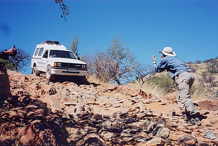
VEHICLE: 4X4 required except for Opuwo to Epupa Falls. Ensure it is in good mechanical & electrical condition; help is a long way away. Two vehicles is strongly recommended. Consider the potential impact on other visitors if you were to require a towing from a remote location.
TIRES: Newer tires recommended. Low pressure for sand and high pressure for rocks and everything else. Bring a pump. Tubeless tires can be repaired on the road using a plug set. Most people travel with 2 spare tires. We had no punctures but we drove carefully and slowly.
FUEL: Diesel engines need half the fuel that petrol engines do. We brought about 265 litres of petrol for the first leg of our trip and wished we had brought more for sidetrips. This amount would be sufficient for a standard circular visit to the Kaokoland (about 900-1,000 km). Fuel is available in Ruacana, Opuwo, and Sesfontein only.
WATER: Opuwo water is saline and chlorinated. Puros camp water was very good. Other water is available along the way (Epupa Falls, Marienfluss, Orupembe and misc. bore holes) was suitable for washing but not potable without treatment. We traveled with 100 litres of water which allowed for daily bucket baths.
WEATHER: We found it warm in winter (July/August). It must be hot as hell in summer. Cool nights at higher elevations. The western edge was cooler (moderated by Atlantic winds). It was windy and sandy at lower Hartmann's Valley and at Armspoort. A fleece AND jacket were useful on some cool evenings.
NATURAL HAZARDS: Few snakes were encountered. We did encounter many thirsty bees that would swarm around the campsite and crawl over everything. At first sight of bees, put all water and objects containing moisture into your vehicle; this should avoid a huge influx of bees. Flies can be annoying. A few mosquitoes (malaria is present) were seen at Opuwo and Puros so bring repellent. And give the desert elephants (in river beds) plenty of room; it is their place!!
CAMPING: Community campsites and wild camping (bring own water). Please dig a hole for the campfire, then cover it in the morning. Same goes for latrine. Please burn toilet paper; no one wants to see your toilet paper blowing in the wind.
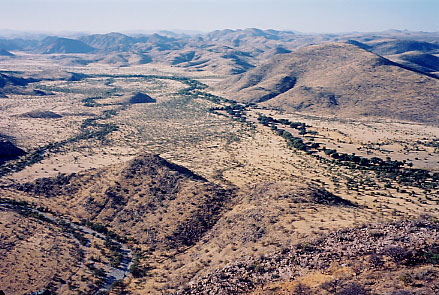
Click on the photo to
see the full size picture.
Position the cursor on the picture for the description.
DRIVING: Slowly to avoid punctures and to enjoy the scenery. Keep to existing tracks. A few tracks were tediously slow (rocks) such as Van Zyl's Pass approach and Otjihaa. We spent most of the time in first and second gear.
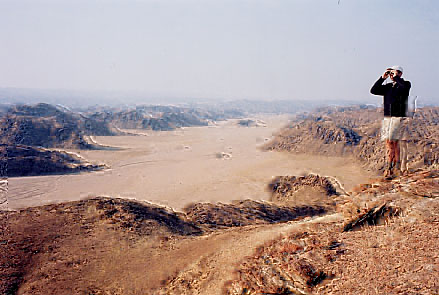
HIKING: Terrific!!! We did day hikes only. Early starts or late afternoon walks made sense as it was hot at mid-day even in winter. Most visitors do not get out of their cars except at campsites. Hiking meant wandering across grasslands but mostly up to viewpoints sometimes involving easy scrambling. There are no hiking trails but there are some game trails.
WHERE TO HIKE: Our Suggestions include…..
Epupa Falls; upstream and downstream of the falls, near the track that leads west of the airstrip for a nice canyon and peaks.
Van Zyl's Pass; from the Marienfluss look-out (we camped at the look-out)
Marienfluss: the wide valley means long approach walks from the road. In the lower valley area opportunities include about 5km north of the community campground or the elevation west of the same campsite.
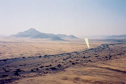
Hartmann's Valley; upper, middle and lower sections are all very interesting.
Orupembe area: plenty of opportunities
Khumeb River: no shortage of good hiking in valleys or up to peaks.
Puros: the daytime sun and temperature was very hot. River bed walking. Overnight hikes with donkeys along the riverbed can be arranged with the community camp.
Hoarisib River: easy scrambles offer big country downstream of Puros
Click on the photo to
see the full size picture.
Position the cursor on the picture for the description.
Hoanib River: plenty of rambling to the north and west of Armspoort. There are plenty of possibilities elsewhere including the ridge on the east side of the Obias River that provides great vies over the Hoanib, Ganumub river area also very good.
HIKING EQUIPMENT: light boots were sufficient. Heavy boots would provide more support but they would be hot on the feet. Sunscreen and hat are essential. Grass seeds get into socks and become a real irritant in many central and eastern areas so we recommend ankle gaitors.
GENERAL TOURING "SWEET SPOTS": Epupa Falls, Marienfluss Valley, Hartmann's Valley, Orupembe Region (including Onjuva Plains), Khumeb River, Puros, Hoarisib River, Armsoort, Hoanib River.
HIGHTLY RECOMMENDED NORTH-SOUTH ROUTE: Sesfontein, Ganumub, Dubis, Armspoort, Tsuxub River, Hoarisb River, Puros, Hoarisib River further 30 km to gorge, track over to Otjovaurwa, Khumeb River, Orupembe, Onjuva Plains, Red Drum. This route avoids the courrugated road west of Puros and the not so interestig road west of Orupembe. The Puros to Orupembe section is not well known but highly recommended.
TRACKS NOT ON THE MAP BUT OF INTEREST:
Click on the photo to
see the full size picture.
Position the cursor on the picture for the description.
Khumeb River: track is on east side with nice views north of Otjovaurwa then it slips into the riverbed to connect with the main Puros to Orupembe route.
Connecting road between Hoarisib and Khumeb rivers: climbs out of Otjovaurwa and joins the Hoarisib about 30 km north of Puros on the west side of the first canyon north of Puros. Continue into Puros on either a track on the eastern side of the Hoarisib or inside the sandy riverbed.
Etanga to Onjuva Plains: Sometimes slow going but OK. We went through Otjihaa but we suspect we should have stayed on the southbound track (map point approx 12 deg 52' E, 18 deg 0'S) that would have also brought us more directly to Onjuva Plains.
Tracks on western side of Hartmann's Valley: there are some interesting tracks to be found. It is apparently possible to drive the entire length of the valley on these tracks on this track west of the main track.
RUACANA TO EPUPA FALLS: We did not drive this stretch. The 100 km from Swartbois Drift to Epupa is rough (about 10 kmph) often within sight of the Kunene and plenty of (begging) Himba.
Click on the photo to
see the full size picture.
Position the cursor on the picture for the description.
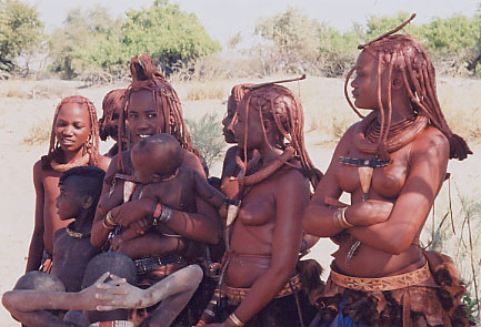
HIMBA: Where there is water, you will find these fascinating subsistence herders. Greatest concentrations seemed to be along the Kunene, along the mid and upper Hoarisib and around Opuwo. They are more traditional to the north. A custom of asking for gifts from visitors has evolved with increased tourism (begging). Sugar and tobacco seem to be the most requested. Blankets are prized. Kids often run to the road calling "sweety", especially on the well traveled Opuwo to Epupa Falls road. Pens and paper are appreciated by school kids. Pain killers sometimes requested. Effective eye drops and ear drops would be of use. Sadly, gift giving is now widely expected, you will feel without, so you may as well bring something. The Himba don't gain much else from your presence.
SECURITY: The Himba are honest and respectful of other people's property. Locked vehicles left alone are apparently very safe.
Click on the photo to
see the full size picture.
Position the cursor on the picture for the description.
OMBUNDE RIVER: Access from Kkhwarib Schlucht of the kandescha Vet fence control point. Nice access route between Kamanjab and Sesfontein. Desert elephants and giraffe are found in the eastern section about 15 km west of Kandescha. Lightly travelled. Cattle found within 10 km of Kandescha. 1-2 nights with day hiking for views is recommended.
LARGE MAMMALS (AUGUST 2002):
Hoanib: elephant, giraffe, gemsbok, springbok
Tsuxub: gemsbok and springbok
Hoanisib: elephant, giraffe, some springbok and gemsbok
Khumeb River: giraffe, some gemsbok and springbok
Orupembe area: mostly springbok, some gemsbok
Munutum (west of Orupembe): gemsbok and springbok
Hartmann's: gemsbok and springbok herds
Marienfluss: some gemsbok and springbok herds
Klipspringer, suricates, baboos also encountered periodically
SOUTHERN AFRICA TRAVELOGUE (2002 4x4 TRIP)