Glenn & Sheila’s Pacific Crest Trail Walk 2003
A journey of a thousand miles begins with a single step. - Lao-tzu (604 BC - 531 BC)
*************************
THE HIKE
Idyllwild, California USA. May 28, 2003.
* Planning for our next misadventure of hiking the length of California along the PCT exposed us to new terminologies....
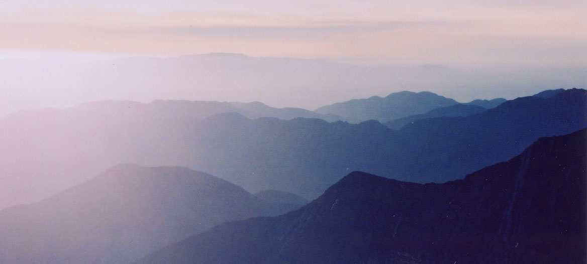
- PCT: Pacific Crest Trail. 2685 mile hiking trail from the Mexican border to the Canadian border. It is not a coastal path; it often folows the desert divide, the Pacific Ocean is a long way from the trail. "Crest" means the trail stays high so the ups and downs are as punishing as its overall length.
- Thru hiker: someone intent on walking the length or considerable distance of the PCT.
- Trail Angels: people who assist the thru hikers by stocking water caches in dry parts, provide accomodation, transport, etc.
- Zero day: no mileage rest days.
- Mush butt: not certain what it is but some people get it further along the trail.
- Miles and feet: pre-metric units of distance in use in USA.
* A review of PCT internet bulletin boards revealed some of the issues we will face. Should I bring an umbrella? ice axe? my dog? a gun? All provided interesting reading. We carry umbrellas (for shade).
* We undertook a rigorous prepatory training program. Two weeks in advance of the hike, we began by walking an hour each day. We peaked quickly so we eased up in the next week. Finally, we both got very short haircuts to make ourselves more stream-lined.
* Greyhound bus travel is less glamorous than air travel, nevertheless, it attracts an eclectic following. The Calgary to Vancouver section had a fairly cosmopolitan crowd; English, French, Spanish and Hindi were widely spoken on the bus. By Southern Oregon, passengers had to pass through metal detectors before boarding the bus and passenger conversation volumes increased. By the time we reached Los Angeles, it was more like a "Jerry Springer" show aboard the bus.
* Our 49 hour bus journey brought us to San Diego, a real nice city. Passing strangers even say Hello in San Diego.
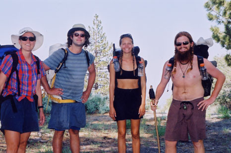
* We began the PCT about 50 miles inland. Border patrol helicopters provided the first night's backdrop. We crossed our first major milesone, an Interstate Highway. It was a disappointing challenge because we had expected to run across the highway, the the trail merely passed beneath an underpass.
Click on the photo to
see the full size picture.
Position the cursor on the picture for the description.
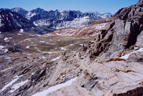
* Wildflowers and cacti are still in bloom after a realtively moist Spring. Southern California is surprisngly green. From the lovely cool pine forests of the Laguna mountains, we peered down into the oven of the Anza-Borrego desert far below. Sheila suffered from heat exhaustion as we dropped into the furnace. We somehow managed to survive our first re-supply detour into the 39C (103F) heat of Borrego Springs.
* Further along the trail, we saw our first rattlesnake, we climbed up and down a whole bunch more hills. We gravitated towards 5:00 am (first light) starts to avoid walking under the California afternoon sun. Days were always longer than we wanted, because it is often 10 miles between water points. It is always further than you think, drier than you expect and hotter than you can imagine. Climbing into the San Jacinto mountains brought some relief from the heat, the first real mountain scenery, but more importantly, our first zero days here in relaxing, pine forested Idyllwild.
* Desert temperatures are forecast at 108F today, so the next stretch that drops down to very low elevations will require some imaginative solutions.
TRAIL NOTES
* We are already deeply indebted to the trail angels for providing water at key points, and to Al and Jay, both of whom live in RV's. Al drove us into San Diego to visit a medical clinic early on and Jay drove us out of the Borrego Springs desert heat back into the cooler (32C) mountains.
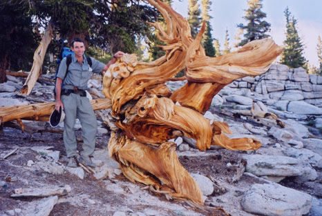
* The woodpeckers on Mt Laguna drill out small holes in the side of pine trees and place an acorn into each of the holes. The woodpeckers return later to harvest the grubs that make their homes in the acorns. True farming birds.
Click on the photo to
see the full size picture.
Position the cursor on the picture for the description.
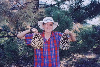
* Be careful where you pitch your tent. Coulter pine cones are the size and weight of large pineapples or small durians.
Click on the photo to
see the full size picture.
Position the cursor on the picture for the description.
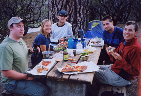
* The other thru hikers are as varied as the terrain. Describing some of our fellow hikers would easily fill a chapter of a book. 58 year old Paul scooting along the trail with his 10 lb pack contrasted young Brian pushing hard with 50 lbs on his back in the 107F afternnoon heat. Conor's blistered feet looked like he had been crucified while Jim and Cindy's dog, Amelia, only lasted a day and a half before its paws all cracked up. Amelia withered in the heat but it is now happily staying with family in Fairbanks, Alaska. Scantily clad "Island Mama"(walking with "thaWookie") sported a golfball size blister on her heel and she commented on how cold sleeping in Southern California can be. She may need to buy more clothes. We don't see many hikers in a given day (somedays none) but a fraternity quickly develops. Last night, 6 of us had a pizza, salad, beer and margarita party in the campground before we all push on for the next 6 days to the next re-supply town.
FOR THE RECORD
******************************************************
UNDER A WARM SUN
Along the Pacific Crest Trail, Agua Dulce, California. June 15, 2003.
* At Idyllwild, we were faced with an epic descent and a desert walk in a California heat wave. However, we understood that the crossing of the I-10 Interstate was once again beneath the road. Lacking a real challenge, we opted for a complicated but successful hitch-hike that brought us into the San Bernardino mountains. Clearly, our status as "thru-hikers" was seriously undermined. We faced an identity crisis. Are we now simply "section hikers"? We settled on "thru-hitchers".
* We passed near the children's book sounding Big Bear City through conifer forests then onto the Deep Creek area. For people who have been hiking or even hitching through the thirst land, a large creek that you can swim in is a memorable experience. The world-class Deep Creek hot springs (foot access only) does change your life.
Click on the photo to
see the full size picture.
Position the cursor on the picture for the description.
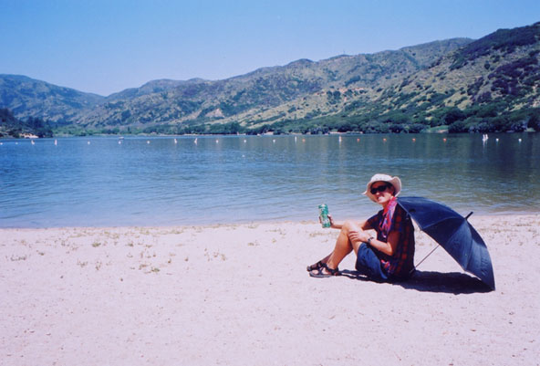
* Further along the trail, we reached Silverwood Lake (what more water?), clearly worthy of another zeroday (what is this, a holiday?). These two not-the-brightest-candles pitched their tent on the luxuriant green grass rather than on the rock hard dirt. At 1:30 a.m. the high pressure sprinkler system kicked in. Our tent survived the 45 minute heavy bombardment. It needed a wash anyways.
* Wrightwood was the friendliest re-supply town that we have passed through yet. Shopkeepers chased us to shake our hands. A supermarket employee took a break so that she could drive home and back to give us something that we could not find on the store shelves.
* We were impressed with the San Gabriel mountains and we were amazed how few (almost none) people we encountered on a week-end when 15-20 million people live within an hours drive away. The 9399 foot high Mt Baden Powell afforded fine views. To the west, the Los Angeles smog was memorable.
* From the San Gabreil mountains, we dropped down beneath the Antelope Freeway to the biggest surprise thus far at the Hiker's Heaven in Agua Dulce. A fantastic couple have opened up a mobile home, RV and a number of large tents in their garden to PCT hikers (the offer seems to include "thru-hitchers also). We sleep in the RV. Donna insists that she does everyone's laundry (temporary clean clothes are provided). Two vehicles are available for hiker's use. What a wonderful world we live in.
* On the topic of wonderful worlds, nearby Santa Clarita, a wealthy northern suburb of Los Angeles, offers an incredible array of stores for the wheels-equipped thru-hitcher. Palm tree lined boulevards and happy motoring from store to store provide a glimpse of the California Dream.We ought to throw in the shoe and buy a car.
* However, our legs and feet are fit. Our relaxed pace thus far has provided good training for the much more demanding and interesting mountains that lie ahead. Our thumbs are well rested for the hitch over the Mojave desert. Next we hike the Sierras.
TRAIL NOTES
Click on the photo to
see the full size picture.
Position the cursor on the picture for the description.
* Interesting trail companions proliferate like the surprising desert mushrooms; they pop up in the middle of nowhere. Sporty Will and Marissa dumped their sleeping pads (200 grams) to lighten their loads. They found sleeping somewhat uncomfortable after that. Ed, carrying a large bag of weed, complained that thru-hikers were always in a hurry and had no time to talk. To complete the PCT in one season, hikers must average 20 miles per day. 67 year old Jane who plans to complete the PCT when she is 70, kept shedding items from her pack along the trail. And so on....
* Hikers often arrive in towns craving fat after a week of dry, lean meals. Ed told us about his Big Mac Xtra large meal followed by a couple of fried fish sandwiches, then a couple more deep fried apple pies all washed down by a multitude of soft drinks at Cajon Pass. We downed a gallon (3.78 litres) of milk one morning.
* You are never alone in Southern California: planes going in and out of San Diego and Los Angeles airports give day dreamers something to look at all along the trail.
* Flower Power: hummingbirds regularily investigate Sheila's red shirt. Apparently, the birds dive at flowered shirt wearers.
* Funnysight: A nude woman at Deep Creek hot springs taking a photograph of a posing (fully clothed) hiker (Ed).
* Forget about the rattle snakes: the PCT is more like a national bug trail. Often they are just gnats, but a cloud of them can drive many a hiker around the bend and then some. They do keep your walking speed up.
* Rattlesnake types we have seen: timber and the western diamond back
* Other interesting critters seen: a wild turkey in flight, a bobcat strolling on the trail and the many horned lizards on the early morning trail that are too cold to move.
* Our float or bounce box that we send along to upcoming re-supply towns never appeared at the Mojave post office. Our conspiracy theory has it that the military at the nearby Edward's Air Force base destroyed the box because of the suspicious smelling spices emanating from it.Editors note: the package re-appeared a couple of days later (X-files?)
*We met Two Deer, who crafts traditional arrows from scratch, while camping up in the high country of the San Gabriel mountains.
FOR THE RECORD
******************************************************
GETTING HIGH IN CALIFORNIA
Dunsmuir,California. July 31, 2003.
After a couple of BBQ’s and more nights in the RV at the Hiker’s Heaven (thanks again Donna and Mark), we set out on our way across the Mojave Desert. Before you get impressions of us walking in the heat complete with mirages and parched throats, we drove across it. Donna wouldn’t even have us hitch hike, so another thru-hiker (George) drove us to Walker Pass.
The next 50 odd miles of mountains remained hot and dry. We passed by our last Joshua trees (cool enough for a U2 title, so we had to mention them) and noisy cicadas, insects that we had previously associated with the humid tropics. We had our first view of the snow peaks awaiting us from Mt. Jenkins. We spent an afternoon cooling off at Chimney Creek with a hose rigged up to make a shower and relaxed in the shade of coulter pines (remember the ones with the durian sized cones) without incident.
Kennedy Meadows is a key milestone because it is the PCT access to the Southern high Sierra. Thru-hikers mill about, changing gear, worry about snow levels, wait for comrades to arrive and then charge north. Further north, we were stampeded by cattle in the middle of the night at aptly named Cow Canyon. At the mouth of Death Canyon, Glenn was struck down by a virulent case of E. Coli. He literally could not get out of bed but we were walking that evening.
Click on the photo to
see the full size picture.
Position the cursor on the picture for the description.
We reached Cottonwood Pass, the beginning of the High Sierra and were greeted by a symphony of military jets from the nearby Edward Air Force Base. Whilst they are supposed to fly 3,000 feet above land, we saw plenty of cowboys flying low in the canyons. Who wants to wander alpine meadows humming songs from the Sound of Music when you can hum the theme from Top Gun? Besides, Tom Cruise is cool and Julie Andrews was way too square.
The scenery moved up a notch. However, Sheila was disappointed with Chicken Spring Lake, where not a roosting free-ranger was to be found, just a wind swept tarn. We camped in the intriguing Siberian Outpost, an open wild part of Sequoia National Park. Our water bottles froze solid overnight. The desert heat was long forgotten and we begain complaining about the overnight cold. Glenn’s brother Steve was right, we should have bought an RV, but then we would be complaining about the price of gas. We’d be more excited to see fighter jets in the wilderness, we would have a bumper sticker that says “Iran next, get more gas” and we would spend evenings playing cards with a card deck of the Iraqi most wanted.
Click on the photo to
see the full size picture.
Position the cursor on the picture for the description.
Although we didn’t “pay our dues” in the desert (we skipped a few bits), our legs were strong in the Sierra. The cooler air invigorated us and we started to put in longer days (over 30 km) on rugged terrain. We crossed over the highest point of the PCT at Forrester Pas (13,180 feet a.s.l.). It had a fair amount of snow and we did an interesting off-trail scree slope descent. We decided to slow down and enjoy the scenery rather than racing through it; since then, we do about 25km per day. Let’s be honest folks, these old bodies can’t do much more than that! The PCT and 210 mile long John Muir Trail (JMT) converge for most of the High Sierra. Many consider the JMT to be the finest trail in the U.S.A. We were very impressed. After over 200 km since our previous re-supply, we detoured via the sublime Bullfrog lake (beauty beyond words) and the stunning Kiersarge lakes to the town of Independence.
Click on the photo to
see the full size picture.
Position the cursor on the picture for the description.
One night in Independence we broke the normal requirements of 3 consecutive days of rain and the campground is flooded to book into a motel on yet another sunny day. Our room featured air-conditioning, hot showers, mini-fridge, coffee maker and a TV with more than 50 channels and still nothing worth watching (except Wimbledon tennis). Independence is a tiny town, so we day tripped it into Bishop. It is a spread out town geared to Sierra tourism, particularly fishing. Postcards featuring over-sized fish and motels offering fish freezing are common. Our real motive for a Bishop visit was to replace our already worn down foam sleeping pads (“Z Rests”) with ¾ length Thermorests. Our hips are eternally grateful. We did not stop there; we shopped at a K-Mart and a Vons supermarket. We even got a Vons savings card. Pretty heady stuff!
LIFE UNDER HEAD NETS
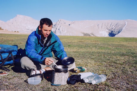
Back on the trail, the military jets were replaced first with the sound of commercial aircraft airspace, then by the buzz of heat & CO2 seeking mosquitoes that were to dog (or bug) us through the remainder of the Sierra Nevada. We passed over a series of high passes between 11,000 and 12,000 a.s.l.. For the first few, it was difficult to see how and where the pass went. We enjoyed plenty of high alpine views and spent much time above 10,000 feet a.s.l. Snow levels did not impede our northern progress.
Click on the photo to
see the full size picture.
Position the cursor on the picture for the description.
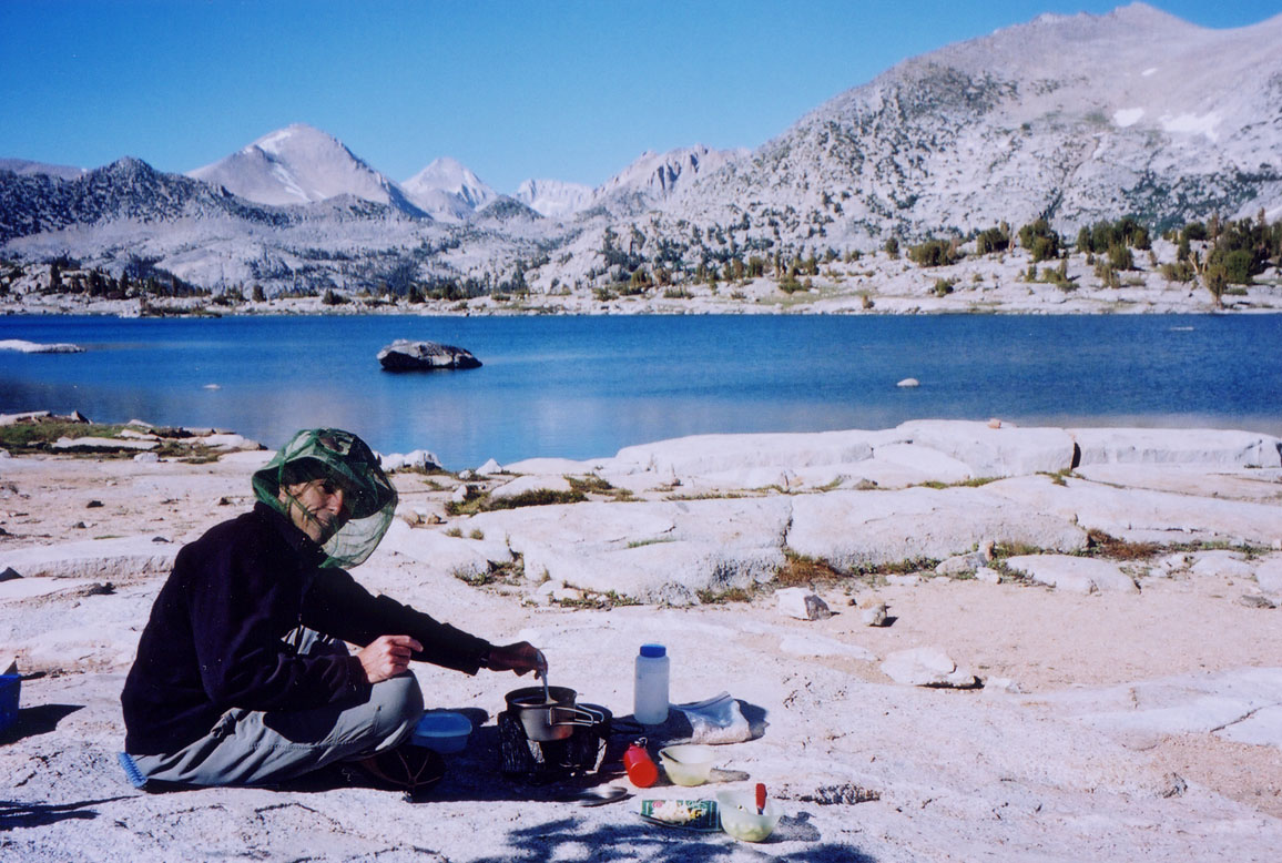
We dropped off Silver Pass near Chief lake, Warrior lake, Squaw lake, Papoose lake and the very intriguing Lake of the Lone Indian and then through a hot spring area. We made our way across our most challenging river ford (a fork of the San Joaquin river) for a warm soak, then visited the Fish Creek hot springs and finally at Red’s Meadow, the public campground had thermal hot water piped straight into the showers. Squeeky clean, we re-supplied in Mammoth Lakes and pushed a shopping cart around enough to save 30 dollars with our new Vons saving card. Mammoth Ski resort was open last season from November 1 to July 5 and there was still snow hanging on the mountains above town.
Click on the photo to
see the full size picture.
Position the cursor on the picture for the description.
Continuing north, these wimps who now sleep on Thermorests, still had it in them to go swimming in a lake at 10,000 feet a.s.l. (Summit lake) that still had snow patches at water’s edge. We carried on into Yosemite national Park and dropped in on the cubby hole post office at Tuolomne Meadows to pick up a food parcel we had mailed from Mammoth Lakes. There were 2 mystery, unsolicited packages waiting for us. “Meander”, a thru-hiker sent us a load of delicious trail mix (thank you Kevin). The folks at packlitefoods.com had found our website, with mail drop dates, and mailed us three light weight trail dinners (thank you Clara!).
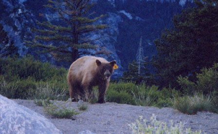
More additional food awaited us in Yosemite. Gail and her son Ivan (Guatemala, 1996) with cousin Justin met us in Yosemite Valley. Gail had filled the car trunk with food for these two hungry hikers. In between eating binges, we visited many of Yosemite’s natural wonders. To cool off in the 97F heat, we swam in the Merced river with Yosemite falls (2500 foot drop) as a backdrop. We cooked up sausages at Glacier Point while awaiting the full moon rise over Half Dome when bear #47 (ear tagged) strolled purposefully towards our dinner. You may or may not have seen the John West salmon clip that circulates on the internet; the one on which the fisherman distracts then kicks a grizzly in the groin to get the salmon. Well, Glenn did not have to go that far but he sure was not going to lose his dinner to a black bear. Glenn stepped forward and set the bear packing.
Click on the photo to
see the full size picture.
Position the cursor on the picture for the description.
We walked some of the PCT's toughest terrain in the granite canyons of northern Yosemite. We encountered a wild bear in Matterhorn Canyon that took off faster than a horse when he saw us (news travels fast in Yosemite). We reached Benson Lake, a.k.a. the Benson Riviera in the midst of the Yosemite hinterland. It is not St. Tropez; no yachts, no cafes but it does have great scenery, sand and a breeze to keep the bugs down.
Urban foks have bad hair days. Hikers have bad bug days. July 18 was about as bad as they get. It was a still muggy, overcast day (first one in weeks) and the head nets went on at 5:15 a.m. and stayed on till we went to bed that night. With our legs still tired from the previous day, we faced gruelling climbs and descents acrosss canyons. We had to swtich over into short pants and we doussed ourselves in our dwindling supplies of DEET. The relentless onslaught of mosquitoes eased to allow black flies to pursue us. We misjudged water availability at one stage to become dehydrated and the RV idea was sounding better and better. Huricane Claudette spilled our first rain that day; mosquitoes reached a frenzy before the storm and thickened afterwards. We literally brushed off the mosquitoes from our clothing before entering the tent that night.
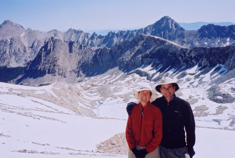
After nine Yosemite nights, we left the Sierra Nevada granite for volcanic structures and a 4 mile walk along the rim of a collapsed volcano (Mt Leavitt). The mosquitoes disappeared and we figured that volcanic rock holds less water and harbour fewer mosqutoes, so we pressed on north. We passed through the Dali-esque volcanic pinnacles near Ebbett's Pass and elevations droped. Temperatures rose to 30C, twisted cedar trees, hummingbirds and ticks all returned. The flowers became more impressive.
The town of south Lake Tahoe offered up a huge array of inexpensive motels, so we could hardly decline their offering. The resort town is a five mile commercial strip and thus offered plenty of long distance walking opportunities. We had a look around a Nevada side casinos but could not see the attraction. Of course, we who slog through snow covered passes and push ther way through mosquito swarms can hardly comment on other people's past times.
The California heat wave continued and our last Sierra section had us cooling off in the lakes of Desolation Wilderness, clambering atop Mt. Tallac for full Lake Tahoe views and sleeping atop high ridges. We reached the I-80, our first interstate since Cajon Pass (I-15 est of L.A.) providing contrast with the beauty of the Sierra Nevada. We met another couple who seemed to be better at PCT hiking than us; they started before us, hiked fewer kilometres and managed extended stays at Disneyland and in Reno.
TRAIL NOTES
Mojave airport offers long-term parking for aircraft. There were plenty of passenger jets there. Apparently the going rate is 100 USD per month (plus shrink wrapping). They don't give frequent parking points but it still sounds like a good deal.
We have met two guys and gals who lost 30 lbs by Kennedy Meadows. Normally, writing about a woman's weight is not done, but this is the U.S.A. where strangers bare their souls on buses and on TV. "Steady" has lost about 40 lbs by the Northrn Sierra and she hopes to lose a total of 65 lbs by trail's end. Many of the gals lose little or no weight but many of the guys lose about 15 lbs in the first month or so. Sheila's personal porter, Glenn, has lost about 15 lbs. Thru-hikers simply cannot eat enough to keep up with the calorie burn.

Click on the photo to
see the full size picture.
Position the cursor on the picture for the description.
Second only to the oils and butter are potato chips for the highest calorie to weight ratio. Instead of carrying dry foods, we are thinking of eating just potato chips. The PCT could be renamed the Potato Chip Trail. "Sunburn" says he makes potato chip sandwiches. We watched him put cheezies and ranch dressing on a wrap (actually a tortilla, but wrap sounds more trendy). Thru-hiker's cuisine.
We are not light weight hikers. On the last section, we hauled lettuce, brocoli, cauliflower, zuchinni, cooked chicken, plums, nectarines and apples with us. If we had a cooler, we would bring ice cream. We eat plenty of legumes. However, Miss Chickpea herself, Sheila, has lately started to crave steak.
Land of the Hamburger: Strangely enough, many protected wilderness areas allow cattle grazing. No motorized vehicles or hang gliders are allowed, but you can bring your own cow. Consequently, a number of thru-hikers came down with giardia in the southern Sierra. We did not meet any thru-hikers walking with their cow.

Click on the photo to
see the full size picture.
Position the cursor on the picture for the description.
We have seen quite a few eastern Sierra towns as we normally re-supply weekly. Town visits tend to be hectic affairs: food store ( milk, beer, ice-cream and calories), the post office (to pick up our "bounce box"), the laundromat, the supermarket, lunch, back to the post office (to send the "bounce box" on), the library (for internet), chase down fuel for the stove, etc. Trail living feels simpler than urban life.
We walked and talked with Dave, a National Park ranger for a couple of hours and got the inside scoop on the central Sierra. He said that ranger numbers and length of season have been cut to pay for the war. C'mn Dave, get with the program, we need war to make peace!
Yosemite bears are well known. It is illegal to leave food in your car in Yosemite as the bears will tear doors off to get at food. We met hikers who had their empty tent trashed by a bear, another who was in his tent when a bear tried to tear its way in, another hiker who was chased off their food by a Yosemite bear and still others that watchd an seemingly unemployed circus bear eat their hanging food bags. We avoided camping in the problem areas of Yosemite.
We met a couple from Manchester, England who were so taken in by the High Siera scenery that they said the mosquitoes don't matter and said "we have bug nets". At first, we thought head nets were a novelty as you feel like a bee keeper. But after a while, when eating, brushing your teeth or going for a pee is a challenge, the novelty wears off.
Helping Hands: We continue to meet many generous people. We had to hitch off the trail many times to re-supply. Dan and Pat rescued us from the roadside on a hot day in Bishop and insisted on driving us to the trailhead the following day. Dan drove 15 miles from home to pick us up at 5:50 a.m. with a thermos of hot coffe. We are thankful for all the people who gave us lifts, especially Chris who detoured to drive us upto Ebbett's Pass.
Thru-hikers: Lance dropped off the radar for a while. It turns out he "kneeded" to rest up his knee so he caught a bus to Los Vegas and stayed for 5 nights. "Be Here Now" sometimes had his trail name shortened to "beer now". "Crazyfeet" hikes on socks only, when no one else has duct tape to fasten his worn out sandals.
FOR THE RECORD
THE FINAL CHAPTER
Calgary. August 18, 2003.
* We had been tipped off that a tragic survival incident involving cannibalism occurred at Donner Pass (actually Donner Lake) so we were naturally concerned when a local chap invited us over for dinner in Truckee. However, our information was a little dated (it happened back in 1846) so we needn’t have worried. Those pioneers must have been lazy, because we found a large Safeway and an Albertsons supermarket a mile away from the lake.
* From Donner Pass, we catapulted ourselves into Northern California with 10 different rides on a warm day. We met all kinds of interesting people and rode in the cab of a cement truck and with a retired Air force pilot who detoured to get us into Dunsmuir (thanks Walt!). The nearby city of Redding was apparently the hottest town on the planet that day (117F or 47C). As we walked into the Castle Crag campsite, Glenn almost stepped on a rattlesnake. We figured that finally the PCT was getting interesting; heat, rattlesnakes, mosquitoes, gnats, lack of water and poison oak make an interesting combination. Little did we know that rain and cold were to be the upcoming challenges.
* The trail through the Klamath Mountains stays high and along ridges providing fine views. We walked for a couple of days with 66 year old “Dr. J”, a retired anthropologist. Dr J and his wife cycled across Canada in 64 days last year. His son joined him for the PCT hike but dropped out after only 5 days (“Dad, this is your dream”). We were convinced these were only cover stories so that he could gain the trust of his latest study subjects, PCT thru-hikers. Once he found out that we were from a different tribe, i.e. PCT thru-hitchers, he zoomed off to the Ashland Shakespeare festival.
* We finally had a break from all that sunshine and had some good old rainy days. For some of the California hikers, it was their first experience with hiking in rain. We stopped in on the lovely isolated town of Etna and stayed in a “hiker-friendly” B&B. The migration of the thru-hikers was near its peak (14 of us in town) and the only restaurant in town could not cope with our appetites and it closed early that evening due to a shortage of food.

Click on the photo to
see the full size picture.
Position the cursor on the picture for the description.
* We pushed on further north past cows with bells in the Trinity Alps wilderness, granite canyons in the Russian wilderness, inviting lakes and Marble Mountain. Mt Shasta, a snow covered volcano, was often visible to the east from the trail. It was time to return to the real world. We eased back into civilization by staying in a remote campground that had real pit toilets and tables. We first walked a gravel road, then a paved road (with heaps of delicious road side black berries) into the hamlet of Seiad Valley (population, an optimistic 350).

Click on the photo to
see the full size picture.
Position the cursor on the picture for the description.
* Seiad Valley is the home of Rick’s pancake challenge; eat all 5 of the thick dinner plate sized pancakes in one sitting and they are free. Polaroid pictures of the successful challengers adorn the walls of the small diner. 7 people have eaten all 5 of the in the last 19 years. Rick says that it is like trying to put 5lbs into a 3lb sack. We had one pancake each and we were full. “Highlife”, a thru-hiker was primed for the challenge. He had stretched his stomach the previous day and felt confident but struggled after two pancakes and put on a valiant effort to eat 3. "Highlife" lost a bet on it and he will be wearing woman's clothing for a trail day and a town day. Rick told us that two days earlier, “So Far” gained a new trail name, while trying the challenge; “Up Chuck”.
* We pulled off the trail at Seiad Valley. We felt very satisfied with our three months on the trail; we saw much of the Southern California mountains, walked the length of the Sierra Nevada and we had a good look at the Klamath Mountains. A few hitches later and two nights on the Greyhound bus brought us back to Calgary.
TRAIL NOTES
Exotics: We saw plenty of the carnivorous California pitcher plants. We also came across a couple of species of aquatic salamanders. We are not sure if these species moved onto land but preferred H2O and returned to water or they were too lazy to leave the pool in the first place.
Most asked questions by day hikers: Where are you going? Where did you start from? Are you going all the way? How heavy are your backpacks? How many shoes have you gone through? Do you get bored of all the scenery? How do you re-supply? What do you eat? And even “what do you think about all day?”
Hitch Hiking Theories: Over the summer we had 45 different rides (all much appreciated). We drove in a Cadillac, a BMW, a bread delivery truck, a cement truck, in the back of a few pick-up trucks, with families, a park ranger, retirees, etc. We found quiet roads much better hitching than on busy roads or Interstate ramps. About half the vehicles were pick-up trucks or SUV’s. 3 out 4 rides were with single occupants. 3/4 of the drivers were male. 1/3 of the drivers were over 50 years old. 10% had dogs in the vehicle. While 60% of the lifts were the classic single occupant–white-male driver, 1 in 6 were single occupant-white-females.

Click on the photo to
see the full size picture.
Position the cursor on the picture for the description.
FOR THE RECORD
TJ Forrester's Twenty-Four Hours in the Life of a PCT Thru-Hiker